On June 18th Black Creek Outfitters hosted a Guru Session led by Jack Stucki, with help from Evan Fullford. The subject matter was The Wonderland Trail, a hike 93 mile that takes winds around Mt. Rainer in Washington state. Jack, a veteran of the area, is making the trek again this September and felt his planning was better shared.
The Wonderland Trail is a must for any hiker. If you are unfamiliar with the trail go to the National Park Service official site here. Apart from this site there are many hikers who have wonderful blogs detailing their adventure.
The Guru discussions occur every Wednesday evening, with pauses in the series based on availability as well as breaks for planning and actual outdoor adventuring. If you are in the Jacksonville area and would like a session dedicated to a specific topic you can reach out to me or ask for Jack when you visit the store.
* Jack recommended going through Seattle as opposed to Portland (flight)
* Jack has hiked the 93 miles three times. Twice with his daughter, the other with friends. More than an handful of time he traversed it as a partial hike. (confirm this, along with dates)
* He is once again planning a hike and thought he’d leverage his planning experience to share with others.
* Folks tend to hike it clockwise, starting at Longmire. Jacks states it doesn’t matter where you start. As a participant noted, “Its’ uphill both ways.”
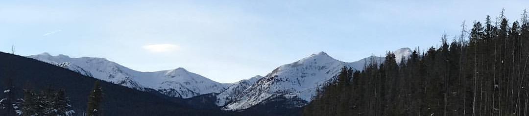
* Trail is on Mt. Rainer.
* Going with his wife and daughter.
* Loaded with switchbacks, thank goodness. “The good folks in Washington know what a switchback is, unlike those in Maine. I wouldn’t hike it if there weren’t switchbacks.”
* Trail goes around the mountain.
* The two times Jack went he started at Paradise Inn. Nice place to begin and end.
* 25 permanent glaciers. Water is not going to be an issue for year round hiking.
* 9 wilderness backcountry camping areas. Flowers on 75 days a year. Hard for foliage to adapt. You must have permits to hike. Middle to the end of April. This year it’s first come first serve due to the number of requests. They will hold out permits for walk ups.
* Many day hiking trails start near or at Paradise Inn.
* Camp Muir, at 10k ft, is where folks begin their ascent. No need for axes or crampons. Cascades, Rockies, Mt. St Helens and even Oregon are visible.
* Main months of the year to hike the trail, August and September if you don’t want to get rained on. Jack did see snow in late September once. August is the best for dry hiking. Twice as much rain in September. May and June are the worst.
* Mid to late September the inns start shutting down.
* Permits are normally done by mail, save this year. 4 ranger stations to get permits at the 4 entry points.
* Typically it’s a 10 to 12 day hike.
* Jack’s advice: hydration and moderation. Start with short days and get your double digit days later.
* “You climbing the mountain?” Said the Ranger to Jack. He learned you can mail packages for refilling. Don’t pack for the duration. Mail it 2 or 3 weeks before you need it. Must be in a hard plastic container. Name and permit number required.
* They’ll stop you on trail and check your permit.
* They will help you change your permit if the trail is impacting your travel time.
* Kilpatche is “phenominal”. Summerland and Indianbar “the most beautiful place on the planet. Also Goatrocks.”
* You’ll go through rainforests with wide trees, traverse glaciers, meadows of “crazy beautiful wildflowers”
* The gear list – Jack’s Big Four – Osprey Exos 58 M Backpack 40 oz, Big Agnes Fly creek UL3 tent w/footprint, 27 oz, Marmot Hydrogen 30′ sleeping bag 21 oz, Thermarest NeoAir Sleeping pad 14 oz, Sea to summits backpack cover 4 oz, 96 oz.
* Evan noted “hiking Washington is like hiking the Alps (Germany)”
* They do not allow campfires. You can for car camping.
* Most of the rives have bridges. But in July and August, as the glacier melts, the bridges will be overrun by rising water. Note warnings about the need to be across bridges before specific times.
* Jack’s hiking in his Salomon XD shoes.
* Make sure your gear is water proof. Storms can come in hard and stay longer than you’d like.
* Gators are not necessary.
* Jack is using a High Tek gravity filter. (I need to confirm the name) A lot of sediment in the water. Look for clear water. Be prepared in case your filter get’s clogged.
* Klipatche Park photo was gorgeous. Mountain reflecting in the lake with mist on the water. Water was very filterable.
* Upper 30’s to upper 60’s in September.
* Great story about Jack’s military buddy who needed a “plan” to cross the suspension bridge. When everyone else sat, Jack crossed.
* Additional story of a man’s young son who shook the bridge while he and his father were reaching the mid point.
* Story of a guy washing himself in the water with Zest. Jack was convincing him to be more mindful when the ranger came by and grabbed the bar with no questions asked by the hiker. Keep nature natural is the lesson.
* One of the most pristine places Jack has been. No trace camping is very relevant here.
* Deer, black bears, elk, marmots among some of the wildlife you’ll see.
* Marmots are blonde on one side. When hibernating they urinate on themselves which gives them the yellow coloring.
* 3 or 4 groups sites. > 4 in a party is a group site requirement.
* Jack is taking a tent and 2 hammocks.
* They may give you a cross country permit, if you show your are a mindful and experienced hiker/camper. You might need this if you get some, but not all permits.
* Shuttle service from CTAC no longer exists. Options are now a rental car, cab or Craig’s List. (92.2 miles 2 hr 15 min driving.)
* 8 to 9 hours of sunlight in September
* They now have bear boxes. Haven’t had bear issues in years.
* Campsites are anywhere from 4 to 10 miles apart, typically.
* Southern and Western are most forested. Northern and Eastern you can see forever.
* Trails are mostly dirt. Minimal rocky spots.
* 1,507 irrigation steps between Summerland and Indian bar.
* 6700 and 2000 ft (highest and lowest elevation)
* If you’re lucky you’ll see a lenticular cloud. http://www.bing.com/search?q=lenticular+cloud+mt+rainier&qs=OS&pq=lenticular+cloud+mt.+&sc=2-21&sp=1&FORM=QBRE&cvid=a778a41a2fc24b048892bc40d0a0cf4d
* Recommendation – don’t rent a car on Seattle airport property. Taxes and fees will double the cost.
* NBylon pants, Smartwool toe socks, Icebreaker Merion hirts for warm and cold days, fleece jacket, rain gear, gloves and skull cap, Icebreaker wool long bottoms in case the temp dips.
* 30 degree sleeping bag (down) 20 oz is Jack’s choice.